* Harihar fort is located in the Nashik district of Maharashtra. It lies at an altitude of 3,676 ft from the sea level.
* The hill on which the fort is built looks like a rectangular shape from the base village. But it is built on the triangular prism of rock during the Yadava dynasty. The edges of the Harihar fort are almost vertical.
* The attraction of Harihar fort is the iconic steps to the top of the fort. It is almost 80 degrees vertically inclined.
* There are Lord Hanuman, Shiva and Nandi idols and a small pond at the fort.
* The view from the fort is beautiful. You can see many forts and peaks such as Bhaskargad or Basgad, Anjaneri fort, Brahmagiri and Utwad fort from the top.
Table of Contents :
Just like you, I love trekking! And this is a trek I’ve documented in great detail to help you do it on your own.
So for better understanding, use this section of Table of Contents :
- What to Watch out for
- Trail Information
- Best Season to do the trek
- Difficult Sections
- How to Reach the base of the trek
- Permission, Water Sources and other finer details about the trek
- Nearby Places to Visit after the trek
- Things to Take for the trek
What to watch out for.. :
The iconic steps that lead to the top of the fort :
The most thrilling part of Harihar fort trek is climbing the almost vertical staircase that leads to the top of the fort.
These narrow steps are carved on the rocks. There are notches carved in that helps to keep your fingers while climbing up.
Do not look back while climbing if you are afraid of height. It is frightening to see the steps you have just climbed up. However, the view behind you is just out of the world!
The first part of the iconic steps. Spot the Mahadarvaja at the end of it.
Stunning view of the Sahyadri range from the top :
Harihar fort offers a 360-degree view of the Sahyadri range. If you are trekking in the monsoon you can see the lush green forts and peaks.
Bhaskargad/Basgad, Utwad fort, Anjaneri fort, Brahma Parvat, Navra-Navri peak, Brahmagiri and many more forts can be seen from there.
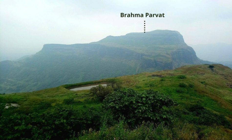
Brahma Parvat as seen from the Harihar fort.
Trail Information :
Harihar fort trek can be divided into 2 sections based on the difficulty level.
1). Nirgudpada village (Kotamwadi) to the plateau: 1 hour 15 minutes.
2). Plateau to the top through iconic steps: 1 hour 30 minutes.
The plateau can also be reached from Harshewadi village. It is marked in purple colour in the below route map. For detailed trail information, go through the explanation given below.
Trail Map of Harihar Fort Trek. Source: Google Earth.
Section I : Nirgudpada village to the plateau (Before the iconic steps)
- Trek Distance: 2.4 km
- Trek Duration: 1 hour 15 minutes
- GPS coordinates of the starting point at Nirgudpada village: 19°53’47.99″N 73°27’19.36″E
- GPS coordinates of the Plateau: 19°54’25.61″N 73°28’0.75″E
The Harihar fort trek starts from the Kotamwadi village which is 300 meters from Nirgudpada village. The exact location where you need to get inside the village is opposite to the Harihar dhaba. It is very close to Nirgudpada bus stop.
Kotamwadi village from where the trek starts.
Once you start the trek from the village towards Trimbak region, the trail is pretty simple. You pass through many fields and small streams. The trail continues to be the same for another 20 minutes.
Starting trail from the Kotamwadi village.
Spot the Harihar fort towards your right while passing through the village.
Harihar fort as seen from the trail just after the village.
The trail starts gradually climbing up once you cross those fields. From here you need to pass through forest and clearings where you can see the fort.
Pro Tip : Wear proper trekking shoes. Carry a pair of trekking poles as well if you have. These 2 trekking gears help you while trekking.
If you are trekking in the monsoon season, you get a small stream just after you cross those fields in the village.
A small stream, on the way to the plateau.
There are arrow marks painted on the rock. But during monsoon season it becomes difficult to spot them.
After trekking for another 45 minutes on the same trail, you reach a plateau. The route from Harshewadi also joins here.
From here you can see the most challenging part of the trek, that is the Iconic steps. Observe how beautifully steps are carved on the almost 80 degrees vertical rock.
The iconic steps, seen from the plateau.
Section 2: Plateau to the Harihar fort top via iconic steps
- Trek Distance: 1 km
- Trek Duration: 1 hour 30 minutes
- GPS coordinates of the Plateau: 19°54’25.61″N 73°28’0.75″E
- GPS coordinates of the Harihar fort top: 19°54’16.4″N 73°28’19.8″E
There is a small stall at the end of the plateau. Take a small break here. Prepare yourself for the very exciting and challenging trek that is awaiting in front of you.
These rock-cut steps look scary but once you start climbing them, you have enough support there for your safety. So it is not scary as it looks from far.
The iconic steps that lead you to the top of the fort.
There are notches carved in for support. Make sure you take the complete advantage of them. Place your foot carefully. During monsoon season they become slippery because of the moss formation.
Pro Tip : Do not turn back while climbing the steps if you are afraid of height. It looks very scary.
Harihar Fort : 80° Ascend During Monsoon
There are around 90 steps before you reach the Mahadarvaja. They are maintained pretty well compared to other forts in that region.
The iconic steps you climbed up. This is captured from Mahadarvaja.
After the Mahadarvaja, the trail takes you to a left traverse. Here, your left is open to a valley and your right is the wall of the fort. You can see the Harshewadi village on your left.
This is the traverse you take after Mahadarvaja. The left side is where you see Harshewadi. Do not forget to capture the view.
Pro Tip : Watch out your head. You need to bend down and cross this stretch. This leg of the trek is very narrow. Only one person can proceed at a time.
Once you cross the traverse, you encounter another set of steep steps. You have to climb up around 100 steps to reach the top.
The rock-cut steps you encounter after the traverse.
After climbing those steep steps, you pass through a small cave. Almost an hour of an exciting climb, you reach the fort.
A cave-like structure you pass through before reaching the fort.
On the fort, you can see small ponds, a temple of Lord Hanuman and Shiva. You can also see a Balekilla which means the highest point of the fort.
Shiva and Nandi idol on the fort. There is also a pond in front of the idols. The hill which you see on the left is Brahma Parvat.
Hanuman temple on the fort.
After exploring a bit on the fort, head to the highest point of the fort Balekilla.
The highest point of the fort seen from the temple.
Another 10-15 minutes of a trek leads you to the highest point of the fort. The top is very small. Only a few people can stand there.
Take some time to get absorbed in the 360-degree view of the Sahyadri’s Trimbakeshwar region. Enjoy the mesmerizing view of all the famous peaks and forts completely immersed in lush green colour.
Bhaskargad or Basgad, Anjaneri fort, Brahmagiri, Utwad fort, Phani Dongar hill which has a needle-like structure and many other forts are around you. It is fun to identify all of the forts and peaks if you are in a group!
Brahma Parvat as seen from the Harihar fort.
Phani/Fani dongar hill that has a needle-like structure. You can see this peak from the top of Harihar fort as well as from the base village.
After spending an hour at the top, you can start to descend. It is the same route you have taken to climb up.
You need to be very careful while descending the iconic steps. Always have the “There point contact” while facing the mountain. Three-point contact is a safety technique where you use 2 hands and one foot. Here is a video that explains three-point contact safety.
Best Season To Do The Harihar Fort Trek :
The best time to do Harihar fort trek is from June to February. During this period you can see the spectacular views from Harihar fort.
Monsoon is the best season to see the lush green Sahyadris. All the fields in the villages and trails will be full of green grasses.
Post monsoon season offers a clear view of the famous forts and peaks from the Top. You can expect the pleasant weather during this time.
Harihar fort, surrounded by lush greenery. You can also see all the streams full of water.
Pro Tip : Weather can be extremely hot during the summer. So trekking to the Harihar fort is not recommended.
Difficult sections on the Harihar Fort Trek :
The challenging section on Harihar fort is the Iconic steps that lead to the top. Both the staircases before Mahadarvaja and after can be slippery during monsoon season.
The moss formation on the steps makes it more difficult to climb. You need to be very careful while keeping your foot.
You can see the moss formation on the steps. This makes the climb slippery and difficult.
There is also a narrow traverse that is tricky to negotiate. Be careful while crossing that section.
Narrow traverse that has to be negotiated very carefully.
How to reach Harihar Fort?
Harihar fort trek has two routes. Both the trails start from villages which are accessible by public transport as well as your vehicle.
The base villages are :
- Nirgudpada(Kotamwadi)
- Harshewadi
Reaching the starting point by your vehicle :
Both the villages mentioned above have roads wide enough to allow cars. Use the links given below to help set up navigation in google maps.
Reaching Nirgudpad : It can be accessed from both Mumbai and Nashik. You can use the link given based on the starting location. If you are travelling from Mumbai, use this link and from Nashik, use this link.
Reaching Harshewadi : This village is closer to Nashik. Hence, people who are coming from Nashik prefer to start the trek from here. Here is the link to reach Harshewadi from Nashik. If you are travelling from Mumbai, use this link to reach the starting point. You can park your vehicle at the village and start the trek. There is enough space to park vehicles.
Reaching the starting point by Public Transport System :
Reaching Nirgudpada/Kotamwadi :
If you are travelling from Mumbai, reach Kasara. From Mumbai CST you get the local train every 15 minutes. You can refer to this chart for more route information. To know more about the timings download M indicator app.
Once you reach Kasara, get a cab to Khodala. It is another junction which is 30 km from there. You get a shared taxi to Nirgudpada from Khodala. The entire travel costs you around Rs 100 to 120.
Pro Tip : If you are in a group of 6 to 7, hire a taxi for a roundtrip. They will take Rs 2000 for the entire trip.
Another way to reach Nirgudpada from Mumbai is to reach Igatpuri by train. From Igatpuri, get into any bus that goes to Trimbakeshwar. Alight at Nirgudpada. Inform conductor to stop you at the destination.
If you are travelling from Nashik, reach Trimbakeshwar. From there get a cab to Nirgudpada.
Reaching Harshewadi :
If you are travelling from Mumbai, get into the local train from Mumbai CST and reach Nashik road. From here take a cab that goes to Harshewadi.
Another option from Nashik is to go to Trimbak by bus and take a cab that goes to Harshewadi.
Pro Tip : If you are in a group of 6 to 7, hire a taxi from Nashik for a roundtrip. They charge you around Rs 1500.
Return option : Return is a problem if you are depending on public transport. You need to complete the trek by 3 pm and try to follow the same route as you reached the base. There will be very few buses after 5 pm from both the villages.
Stay options : Villagers offer you homestays in both the bases. You can also pitch a tent on the plateau which you get on the trek.
Nearest Railway Station :
Kasara Railway station – 60 km
Nashik Railway station – 56 km
Nearest International and Domestic Airport :
Chhatrapati Shivaji International Airport, Mumbai – 170 km
Frequently asked questions about Harihar Fort Trek :
Do we need permission to do Harihar fort trek?
* Harihar fort trek does not require permission from the forest department. You can do this trek on your own without any permission.
Is camping allowed on Harihar Fort Trek?
* There are no restrictions on camping on this trek. However, on top of the fort, there is not much space to pitch your tent.
* You can camp on the plateau just before the iconic stairs. There is enough space available. It is also closer to the village which makes it easier to get food and water.
Are there any food and water sources available on Harihar Fort Trek?
* Harihar trek starts from the villages. And these villages have many small dhabas where you get food. You can even find a small shop on the plateau. You get water and some snacks there.
* If you are trekking during monsoon season, you get many small streams on the way to the fort where you can fill your water bottle. The dhabas near the village will provide water as well.
* Make sure you carry a minimum of 2 litres water along with you.
Pro Tip : If you are not comfortable with having water from outside carry purification tablets or life straw bottles to purify the water.
Who can do the Harihar Fort Trek?
* Harihar fort trek is not recommended for beginners. The iconic stairs can be a bit scary if you are trekking for the first time.
* Any fit trekker who has prior trekking experience can attempt Harihar fort trek.
What is the ideal time to start Harihar fort trek?
* The ideal time to do Harihar fort is to start the trek from the base before the sun starts beating down. So that you reach the top before noon and descend for your late lunch.
* You need 2 and a half hours to reach the top and 1 and a half hours to descend. Make sure you come back to the starting point before 3 pm.
* If you are depending on public transport for your return journey, then after 3 pm, you have only a few buses that go to Nashik or Trimbak.
Emergency contact for Harihar Fort Trek :
* Hospital : Sub District hospital Trimbakeshwar is the nearest hospital to Harihar fort trek.
* Police Station : Harsul Police station, Trimbakeshwar is the nearest police station to Nirgudpada or Harshewadi.
* ERSS : For any kind of emergency help, you can contact the Pan-India Emergency Response Support System (ERSS) number- 112
ATMs and Network on the trek :
* ATMs : Nashik or Trimbakeshwar is the nearest place where you can find reliable ATMs. Therefore, Make sure you carry a minimum of Rs 1000 from your starting location.
* Mobile Networks : There are networks at the base village. But on the trek, only the Jio provider catches the very weak signal.
Places to visit after the Harihar Fort Trek :
There are many other forts and peaks you can explore near Harihar fort. Some of them are:
Anjaneri Fort : It is the only fort where you can see a temple for Maata Anjaneri, the mother of Lord Hanuman. An easy-moderate trek that starts from Anjaneri village.
Bhaskargad/Basgad : It is one of the forts in Trimbak hill region. You can see this from the top of the Harihar fort. It is an easy trek and very close to Harihar fort. One can complete both the fort in a day.
Brahmagiri hill : It is very close to Trimbakeshwara Shiva temple. It is a source of River Godavari.
It is an easy-moderate difficulty level. You can do this trek if you have a couple of days.
Ashoka waterfall or Vihi waterfall : It is located very close to Kasara. You can visit this waterfall on the way to Nirgudpada if you are hiring a private vehicle.
The drive from Kasara to Ashoka waterfall is very beautiful. You can see many small waterfalls on the way.
Ashoka waterfall as seen before reaching the waterfall.
Vaitarna Dam : It is a gravity dam constructed on the Vaitarna river. It is located close to Kasara. You can visit the dam before going to Harihar fort or after the completion of the trek.
Crystal clear Vaitarna dam.
What To Pack For Harihar Fort Trek :
- Basic First Aid kit*
- Identity Card
- Cap/ Scarf/ Bandana & Sunglasses
- Water (Minimum two litres)
- Lemon and salt OR Electrolyte Powder/Drink (Electral/Gatorade/Glucon D, etc.)
- High-calorie snacks (Nuts & dry fruits, home-baked cake, etc.)
- Safety Pins, Rubber bands & Whistle (Useful in emergencies.)
- Quick Dry T-shirts are preferable over cotton tees.
- Poncho, only during monsoons
- Plastic sheet to wrap electronic devices, only during monsoons
- Sunscreen (SPF 50+)
- Optional: Trekking poles
*
First aid kit:- Scissor
- Band-aids (Regular & Waterproof)
- Analgesic spray (Relispray, Volini, etc.)
- Antiseptic Liquid (Savlon, Dettol etc.)
- Antiseptic powder (Povidone-Iodine based powders like Cipladine, Savlon, etc.)
- Cotton roll & Bandage
- Crepe Bandage
- 1-inch wide medical tape (paper or cloth.)
- Micropore tape
- Tablet for motion sickness (Avomine), Acidity (Gelusil, Digene, etc.).
- Mild pain relief tablet (Crocin)
Conclusion :
People in South India, think travel is all about visiting pre-explored and well known places, so that they can happily say/express to others or to the society that they've travelled to Ooty, Kodaikanal.etc. Many travel for their social status. Travel isn't only about social status. It's a kind-off adventure which everyone must do it atleast once in their lifetime. Atleast once in our lifetime, we must visit places which aren't even present in Google Maps (Which I use to follow during my every travel). This is what I think the proverb "Think Out Of The Box" trying to teach us!
See you all in the next week with another great adventure. Until that, Explore More!🌍 Chase Adventure!!😎 TraWell!!!😉


Comments
Post a Comment